WRecKLeSS
Active member
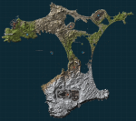
Last Known Coordinates - Chattam (real island name Chatham).
Description: A small island with pockets of water: This map was taken from Chatham Island using terrain.party & importing the heightmap into RustEdit.
Airfield with added hanger, support buildings, trees, roof access, and cover
Launch Site with alternative ways off the roof, crane with ladders, support buildings, cover, happis puzzle, and additional ladders
Bandit Gas Station with cargo containers (maze), outbuildings, refinery, and additional cover
Military Tunnels with added buildings and entrances customized
Harbor with roof access, support buildings and access to light towers
Happis Puzzle compounds with communications RV, refinery
Oil Rig (big and small)
Dome
Hapis style caves (oversized)
The map can be downloaded by joining the server: http://playrust.io/map/?69.195.141.242:39500
Map Author: WRecKLeSS
Feel free to use this on your server but please don't edit. This is a free map for the Rust community. I just make maps because I enjoy the process. You do not have permission to sell this map

Last edited:
